Our heart goes out to all in our community who were affected by the River Fire. This fast-moving fire took the community by surprise, and we are grateful to all the firefighters and community members who helped defend our communities. Unfortunately, there was still an immense loss. We want to offer any support we can to those impacted. In the link below, you can find resources provided by the county and multiple agencies for post-fire recovery. We’d also like to offer our support in the form of conversation and environmental monitoring. Please contact us if you’d like to discuss our path through the insurance process or resources and options for post-fire restoration and other ecological considerations on your land. While wildfires are a natural part of our ecosystem, a history of fire suppression leading to increased fuel loads coupled with impacts from climate change has caused them to be increasingly devastating for the thousands of people they impact throughout California. The River Fire was no different and provided an unfortunate but vital opportunity to learn more about how the “new normal” and “unprecedented” fires burn in our region, much like the Jones Fire last year.
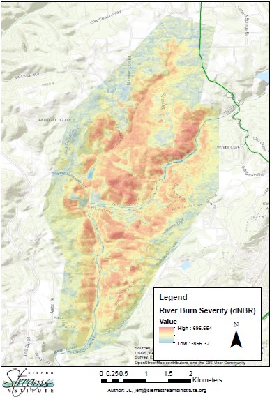
For example, we can map burn severity (Figure 1) using satellite imagery that measures the reflectance of various materials. When these burn severity maps combine with multiple other attributes of an area, such as topography, wind, tree density, ground fuel loads, and even prior treatment history, we can better understand what attributes contributed to various burn severities. Examining which variables were most significant in determining burn severity can give us targets for future forest management. Did fuel breaks slow fire? Did fuel density or topography contribute more to burn severity, and where does low fuel load override steep slopes? Our analysis of the River Fire is only just beginning, but see our discussion of the Jones Fire below for more about the process we use.
But when it comes to ecological impact, once a fire is out, the process is just getting started. Fire impacts soils, biochemistry, runoff and erosion, and water quality. So after a fire, long-term monitoring sites for things such as water quality are critical to getting a snapshot of conditions before and after the fire. Here, once again, the River Fire will provide a unique opportunity to measure fire impacts on watershed health. We started monitoring water quality in the Bear River watershed in 2015, with multiple sites upstream and downstream of the burn scar. We will continue to monitor these sites to better understand the River Fire’s impact on water quality and the animals who call the Bear River home. We expect fires to impact water quality by increasing turbidity (cloudiness) after first fall rains cause lots of runoff and erosion, and conductivity and nutrient content. Conductivity can be changed by increasing or decreasing ions (charged particles) due to erosion after a fire. Nutrients like nitrate and phosphate may also increase following the rains after a fire because the red fire retardant dropped on many of our fires, mainly ammonium phosphate (basically a fertilizer!). Ammonium phosphate is also a salt, which can further modify conductivity. Keep an eye on our webpage and www.riverdb.org for updates on water quality as we enter fall and winter.
If you would like to donate to those impacted by the River Fire, you can do so at: https://www.nevcorelief.org/firerelief/
If you were impacted by the River Fire and need support, you can contact 211 Connecting Point to access the funds raised or find out about other available government emergency resources. https://www.211.org